Arrival Info   Ft.Myers airport   Map of Naples  
 
  Rentals: Villa 14569   NEW:


Sunset in Naples.
CLICK on picture to enlarge. Later CLOSE (x) large picture.
Sunset in Naples
New: NaplesGolf.info


THE SHORES
Rated among the best in the nation, Naples' beautiful beaches invite you to stroll, play and swim. The beaches are renowned for the abundant variety of shells endlessly washing up on shore, and shellers delight in sifting through a mix of sizes, shapes and color.
Delnor-Wiggins Pass State Park, one of Naples' beaches, was ranked as one of the Top 20 Beaches of America, and also features many eco-opportunities. Just south of Delnor-Wiggins, birdwatching and shelling are among the activities enjoyed at Vanderbilt Beach and County Park.

THE SHORES.
CLICK on picture to enlarge. Later CLOSE (x) large picture.
THE SHORES
The Shores is a conveniently located area in Naples, only 6 miles to the beaches and only about 2 miles to the nearest semi-private golf course, where public players are welcome! About half a mile away you'll find a big shopping center with PUBLIX, WINN-DIXIE, and all other important stores. Although not necessary in Naples: The SHORES community is 24 h security gated.
An other highlight for Golfers: Only a miles away you'll enjoy Naples' biggest driving range, which is lighted at night. Please watch the map. Look for the blue DR. It is nearby!
NOTE: Each property is individually owned or managed.


Arrival information:

Car necessary
By car from Miami to Naples Exit 101 on I-75: 107 miles
By car from Fort Myers to Naples Exit 101 on I-75: 34 miles
By car from Interstate (I-75) Exit 101 to The Shores: 2 miles


Description from Fort Myers airport to The Shores

Get free maps from your car rental at Ft. Myers Airport. Before your start read the following description carefully and check it with the maps. When you left the parking lot at your car rental you'll get on a big road named DANIELS PKWY. Go West in direction to Ft. Myers. After crossing TREELINE DRIVE take left lane still on DANIELS PKWY, go "under" INTERSTATE 75, turn left (to SOUTH), and enter I-75 in direction to NAPLES.
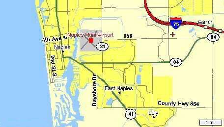
You go on I-75 in southern direction for about 28 miles and you have to leave the INTERSTATE at EXIT 101 (mile stone 111). Keep right and you'll get on CR 951 in southern direction. The 951 is also called COLLIER BLVD. On 951 about 1000 feet you have to turn right into CR 84, DAVIS BLVD.
After half a mile at the first traffic light turn right on RADIO ROAD (Country Hwy 856). 
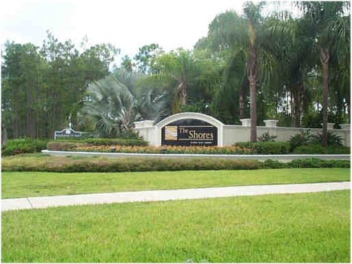
After one mile you'll see on the right side the SHORES.


Map of Naples and The Shores
The red cross marks THE SHORES.
Country Hwy 856 is the RADIO ROAD.
Country Road 84 is the DAVIS BLVD.
The Road next to THE SHORES, going south to north, is the SANTA BARBARA BLVD.
At the intersection SANTA BARBARA and RADIO there is in northeastern direction THE SHORES. In nordwestern direction you'll find BERKSHIRE LAKES (with Publix). At the southwestern corner there is COUNTRY SIDE Golf CLUB (with Winn-Dixie). In southeastern direction is the commnunity PLANTATION.
Map!

  END END END END END END TOP TOP TOP TOP TOP TOP TOP TOP